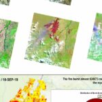
Day 4: When maps serve decisions. 🔥 August 2019. Fires near the Bolivia-Paraguay-Brazil border consumed nearly one million acres in a month. Fire managers needed burn severity maps to prioritize recovery efforts, and I used Landsat 8 imagery from before…
Day 3: Nearly 25 Million Points in a Single File – PDAL Yosemite
Day 3: Nearly 25 million points in a single file. Where do you even start? FOSS4G Bucharest, 2019. Connor Manning and Adam Steer showed what PDAL/Entwine could do with point clouds, and I was hooked. This was the tool I…
Day 2: Mapping Walls You Can’t See From Above – Yosemite LiDAR
Day 2: Mapping walls you can’t see from above. 🧗♂️ Yosemite Valley. Climbers need to understand vertical terrain, but most maps show the world from a bird’s perspective. I used airborne LiDAR at 0.5 meter resolution to create a Digital…
Day 1: The Map That Started Everything – Aiudului Gorges (2011)
The map that started everything. 🗺️ Aiudului Gorges, Romania. 2011. A place close to my heart. I still go there to hike and climb, and I know the terrain well. I was fascinated by the karst topography. The Trascău Mountains…
Closing One Chapter, Opening Another: #100DayMapChallenge
It’s the end of an era, and the beginning of a new one. For over a decade I’ve been building interactive maps and data visualizations. From LiDAR point clouds and GIS workflows to WebGL terrain, network graphs, procedural experiments, and…


