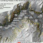
Day 2: Mapping walls you can’t see from above. 🧗♂️ Yosemite Valley. Climbers need to understand vertical terrain, but most maps show the world from a bird’s perspective. I used airborne LiDAR at 0.5 meter resolution to create a Digital…
GIS playground, 3D maps and data visualizations